| Crystal Cove State Park, totaling about 2,800 acres, extends on both sides of Pacific Coast Highway. On the ocean side there are three miles of quiet trails on the bluffs above the beach. The Pelican Point area has the greatest number of accessible trails and an outstanding native plant restoration project. On the inland side, single-track fire roads used by mountain bicyclists run through 2,400 acres of rough terrain in El Moro Canyon. You might skip Los Trancos and Reef Point, where the trails down to the beach are steep. Restoration of the historic cottages at Los Trancos will include accessible parking and some access to the cottages and the beach.
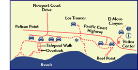
PELICAN POINT
Pacific Coast Highway
at Newport Coast Drive
Lilac, California sage, elderberry, and sunflower—Pelican Point is a plant lover’s dream. The trails immerse you in the coastal sage scrub, home to the endangered California gnatcatcher and many other birds. With a vast network of paved trails, Pelican Point is one of the best places on the Orange County coast for long walks. Group outings with multiple sets of wheels would be very comfortable here because the east-west paths are wide enough for side-by-side travel.
Our favorite paved trail takes off from the west end of the parking area and heads westward, cutting through a landscape rich with plants and birds. Slopes are manageable at a slow pace; at a jog they’re a workout. The smooth pavement is about 10 feet wide. The trail turns south and heads downhill to the beach about .75 mile from the parking lot. We went partway down the hill before it became uncomfortably steep.
We also enjoyed the Tidepool Walk, a southbound ground-level wooden boardwalk through a botanical restoration area. The five-foot-wide boardwalk begins near the restroom building in parking lot number 2 (see map) and runs toward the ocean through drifts of windswept sage. Native plants are labeled with both their common and scientific names. Birds you may see include California towhees, mourning doves, turkey vultures, and white-tailed kites.
The Tidepool Walk ends at the edge of the bluffs overlooking the tidepool area below. Since there’s only a steel cable handrail on the perimeter, the sweeping ocean view is unobstructed. A smaller sand path continues down the bluff. It’s narrow and difficult—definitely not officially wheelchair-accessible—but an adventurer with a manual wheelchair may want to try it. There are some severe cross-slopes at washed-out areas, and the steel cable handrail is not much help. This is the equivalent of mountain biking on a wheelchair. Turn around when you get to the driftwood interpretive sign and the bench overlook, just before the metal cord handrail changes to wood. There are stairs on the next turn and very little room to turn around. The return trip up the hill is tough, and it’s helpful to have someone behind you to push and balance.
Parking/Restrooms
Parking lots, restrooms, outdoor showers, and drinking fountains all have good access. Restroom buildings have large accessible stalls with high toilets, grab bars, and sinks with stiff push buttons.
EL MORO CANYON
El Moro Canyon, a 2,400-acre watershed on the inland side of the highway, has 18 miles of trails, but they’re rough going by wheelchair. The trail on the right side of the road just before the parking lot is probably the easiest, but it’s dusty and steep in places.
The Visitor Center is open sporadically on weekends only. (It’s open only when a volunteer is available.) The center has tabletop exhibits of native flora and fauna.
Restrooms
The spacious accessible restroom at the Visitor Center is open during park hours even when the center is closed. It has grab bars and a sink with stiff push buttons.
|